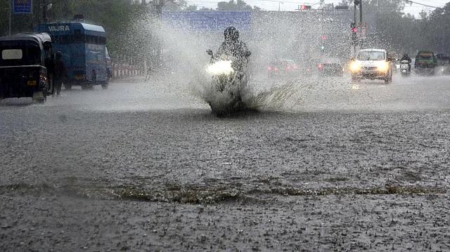
Heavy Rainfall Hits Narmadapuram, Vidisha; Bhopal on Weather Alert
Monsoon has made its intense return to Madhya Pradesh this week. Areas like Narmadapuram, Vidisha, and parts of Raisen experienced continuous showers on July 5, causing waterlogging and disrupting road travel. Meanwhile, Bhopal is on high alert, expecting thunderstorms and lightning in the coming hours. It’s been a wet and uneasy start to the weekend, and according to authorities, the skies aren’t clearing anytime soon.
For many in the region, the abrupt downpour caught them midway during daily commutes. “I left for the market around noon, but within minutes the roads were flooded,” said Ankit Verma, a resident of Vidisha. “Lightning struck somewhere nearby, and it was honestly scary.”
Timeline of Events
Here’s how the day unfolded across central Madhya Pradesh:
- 11:00 AM: Skies began to darken over Raisen and Hoshangabad (Narmadapuram).
- 12:30 PM: A moderate wind picked up, and temperature dropped noticeably.
- 1:10 PM: Heavy rainfall hit Vidisha, stretching into Ashoknagar and adjoining areas.
- 3:00 PM: Parts of Bhopal registered mild showers accompanied by cloud movement and thunder.
- 5:45 PM: IMD (India Meteorological Department) issued a thunderstorm warning for several central districts.
Rainfall estimates hovered between 50mm to 80mm in the hardest-hit districts. That may not seem extreme at first glance, but days like this tend to wear down local infrastructure, fast.
Official Weather Statements
According to the Bhopal branch of the India Meteorological Department (IMD), several central MP districts are under a yellow category warning — which includes potential hazards such as lightning, sudden wind gusts, and short-term flooding in urban areas.
“We are expecting thunderstorms accompanied by lightning over Bhopal, Raisen and parts of Narmadapuram by late evening,” an IMD spokesperson said. “Citizens are advised to stay indoors, especially between 6 PM and 10 PM, as this is the high-risk window.”
The alert also highlighted risks for low-lying areas. With drainage systems already strained, flash floods and roadblocks aren’t off the table – especially if rain intensity maintains or increases overnight.
Impact on Daily Life
The deluge came right as many were out shopping for the weekend or commuting home from work. In Vidisha and Hoshangabad, local businesses reported a drastic dip in foot traffic after midday. In fact, some shops shut altogether as streets became impassable in parts due to knee-deep accumulation.
Electricity interruptions also took place sporadically across Raisen and Ashoknagar with social media showing videos of streetlights flickering and transformers sparking under excessive load.
Here’s how the weather impacted various sectors:
- Road Transport: NH-46 reported mild congestion with slow-moving traffic caused by waterlogged stretches near Obaidullaganj.
- Railways: Trains on the Bhopal–Itarsi stretch battled short delays.
- Local Businesses: Shorter working hours and fewer customers in markets affected daily earnings.
- Public Services: Municipal employees were dispatched midday to unclog storm water drains.
Community Response
Residents have had mixed reactions. On one hand, farmers—especially in rain-fed regions—welcomed the downpour, seeing it as a much-needed boost for crops like soybean and maize. Others, mostly urban dwellers, weren’t as pleased.
“This could’ve waited a few hours,” joked Prakash Solanki, a schoolteacher in Bhopal whose scooter got stuck in a pothole. “But rain doesn’t consult us, does it?”
Social media timelines were flooded with videos of ankle-deep water across colony roads and apartment blocks sharing their own challenges – from wet basements to flickering wires. One short clip posted from near Lalghati Circle showed lightning striking uncomfortably close during an intense cloudburst.
School Openings Still Unaffected
Interestingly, despite adverse conditions, district administrations have not issued closure notices for schools or colleges yet. Parents were instructed via SMS alerts to monitor conditions locally and not to send children out if roads seemed unsafe.
What About Bhopal?
Now, let’s talk about the state capital. Bhopal has been under gray skies all Friday but only received drizzles until late afternoon. That may change tonight if IMD predictions hold.
Rain-bearing clouds, currently hovering across Mandideep and Obaidullaganj, are reportedly moving westward – straight toward the capital region. With wind speeds reaching 20 to 25 km/h and atmospheric moisture at near saturation levels, the stage is set… unless something shifts.
If you’re in Bhopal, the best course of action tonight? Maybe steer clear of open areas, be cautious near electrical poles, and avoid unnecessary travel, especially past 7 PM. Phones are buzzing with alerts for a reason.
What’s Next?
Looking ahead, the weekend doesn’t offer much relief. IMD projections show intermittent rain through Sunday across most central MP districts. No red warnings yet – but don’t be surprised if they update that status at short notice.
Meteorologists point out that Monsoon winds have finally picked up proper pace in the region. The low-pressure area over eastern Uttar Pradesh continues to feed moisture into Madhya Pradesh’s heartland. This could keep thunderstorm activity alive through early next week.
Here’s the forecast snapshot through Monday:
- Saturday: Cloudy skies, occasional heavy showers in the afternoon.
- Sunday: Potential thunderstorm activity post-3 PM across Bhopal and Raisen.
- Monday: Gradual clearing, but scattered rain pockets remain likely.
If weather follows last year’s patterns, locals can expect another strong spell mid-July too. That time might call for stronger interventions.
Stay Informed and Prepared
Authorities reminded people not to take weather alerts lightly. Emergency helplines will be active post-sundown, and disaster response teams have been put on standby near vulnerable areas.
For now, stay dry, stay cautious, and maybe skip that long drive for your next samosa fix. It’s shaping up to be a rather charged monsoon weekend in central India.

